DYNAMIZE AND ADD A MAP
The ADventori enabler allows you to easily add a Google map (static or dynamic).
Google authorization key:
Before using the google maps service you must generate a google maps security key at this adress, and activate the appropriate service (static map or javascript google API).
Term of use google maps : link
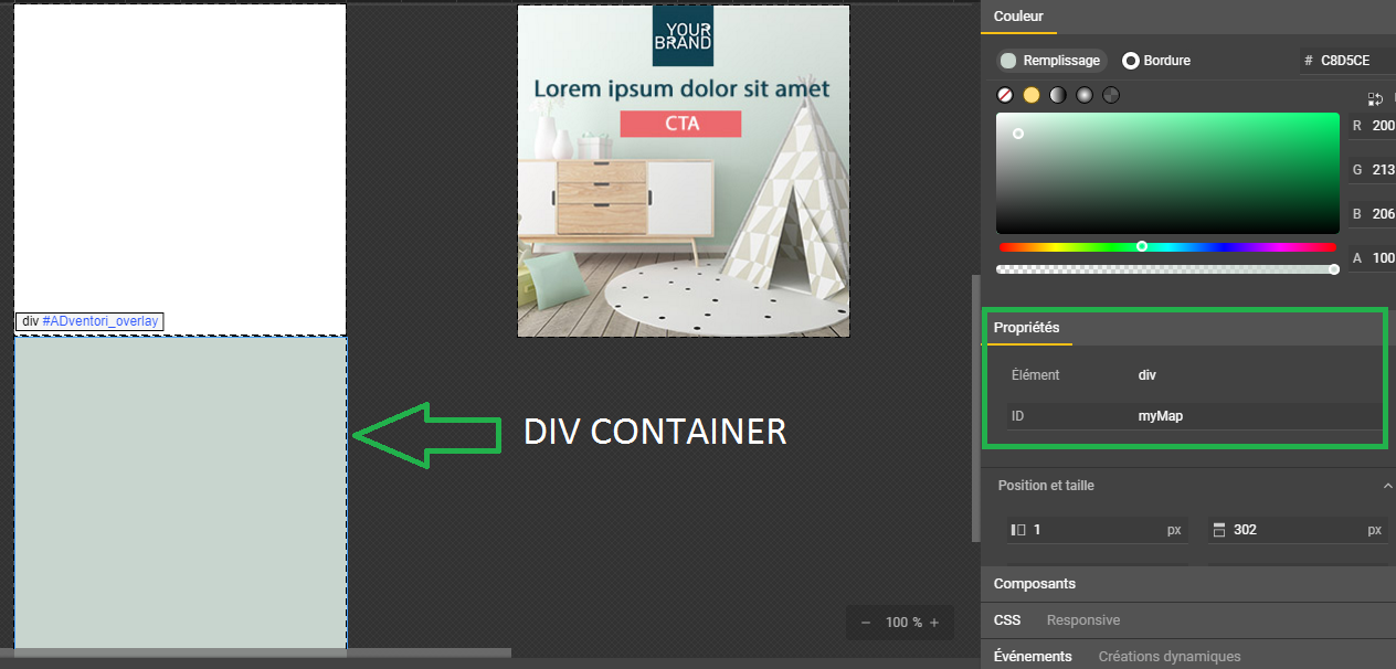
Under Google web designer, create a container and name it (here myMap).
Static map :
official documentation : link
//our dynamic elements that will be updated
ADventori.initData({
	retailers :[
             {name:'PARIS',gmLatitude: 48.856614 , gmLongitude:2.3522219000000177},
              {name:'Clichy',gmLatitude: 48.9, gmLongitude : 2.3},
              {name:'Orléans',gmLatitude: 47.9028900, gmLongitude : 1.9038900}
		],
        markeur : 'http://adventori.com/lp/enabler/templates/Wall_CreaV2/map/html5/static/img/pin.png',
        key:'XXXXXXXXXXXXXXXXXXXXXXXXXX' //votre clé google maps
});

Waiting parameters :

1 : retailers : lists of stores to display with name, latitude and longitude (required)
2 : mapContainer : the container that will contain the map (required)
3 : size : expected image size (required)
4 : zoom : zoom level (optional)
5 : scale : image ratio (optional)
6 : format : expected image format (JPEG, GIF or PNG) (optional)
7 : maptype : type of expected image (roadmap, satellite, hybrid and terrain) (required)
8 : language : expected language (fr, en ...) (optional)
9 : key : google map api key (required)
10 : markeur : marker url (optional)
11 : type : return of the type of the image: image or background (optional)(optionnel)


var map = new ADventori.Maps.StaticMap({
	retailers :ADventori.data.retailers,
        markeur : ADventori.data.markeur, //url icon for markeur
	mapContainer: document.getElementById('myMap'), //div container
	size :'298x299', //size of image
	zoom : 7,  //zoom map
	scale : 1, //scale image
	format :'JPEG', //JPEG , GIF,PNG
	maptype :'roadmap', //roadmap, satellite, hybrid et terrain more details
	language :'fr', //language fr,en...
	key :'XXXXXXXXXXXXXXXXXXXXXXXXXXXXXXXXX', // google map api key
	type:'image' //image , default value  background
});
example :
Dynamique map :
under Google web designer , add library url Google map API directly in interface.
url google map API: https://maps.googleapis.com/maps/api/js?libraries=places&key=XXXXXXXXXXXXX

official documentation : link
//our dynamic elements that will be updated
ADventori.initData({
	retailers :[
             {name:'PARIS',gmLatitude: 48.856614 , gmLongitude:2.3522219000000177} ,
              {name:'Clichy',gmLatitude: 48.9, gmLongitude : 2.3},
              {name:'Orléans',gmLatitude: 47.9028900, gmLongitude : 1.9038900}
		],
        markeur : 'http://adventori.com/lp/enabler/templates/Wall_CreaV2/map/html5/static/img/pin.png',
        key:'XXXXXXXXXXXXXXXXXXXXXXXXXX' //votre clé google maps
});

Paramètres attendu :

1 : retailers : lists of stores to display with name, latitude and longitude (required)
2 : mapContainer : the container that will contain the map (required)
3 : zoom : zoom level (optional)
4 : markeur : marker url (optional)
5 : options : list of options of the dynamic map more details here


 var map = new ADventori.Maps.DynamicMap({
        mapContainer: document.getElementById('myMap'), //div container, //div container,
        retailers: ADventori.data.retailers,
        zoom: 7,
        markeur: 'http://adventori.com/lp/enabler/templates/Wall_CreaV2/map/html5/static/img/pin.png',
        //google map options are avaible link bellow
        //https://developers.google.com/maps/documentation/javascript/3.exp/reference?hl=fr#MapOptions
        options: {
            zoomControl: true,
            mapTypeControl: true,
            mapTypeControlOptions: {
                style: google.maps.MapTypeControlStyle.DROPDOWN_MENU,
                mapTypeIds: ['roadmap', 'terrain', 'satellite', 'hybrid']
            },
            scaleControl: true,
            streetViewControl: true,
            rotateControl: true,
            fullscreenControl: true
        }
    });
example :